Watershed Characteristics, Flood Preparedness, Flood Recovery

The Chain of Lakes drains 1250 square miles.
This is nearly the size of all of Lake County, IL. Over 70% of that drainage basin comes from Wisconsin.
The northern portion of the Fox River in Illinois is extremely flat as it flows through the glacially-formed lakes region, called the Chain of Lakes. The regulatory floodplain area in the Upper Fox River watershed is extensive. Thousands of homes and businesses are located adjacent to the river and lakes in this region. Proximity to the water, provides access for recreation but also places these properties at a high risk for flooding.
The Chain of Lakes is comprised of nine interconnected lakes.
The lakes provide a natural storage area for the Fox River. Stratton Lock and Dam (formerly McHenry Dam), located six miles downstream of the lakes, provides for the annual passage of 17,000 boats and controls the water level in the Chain Lakes to provide a deeper summer recreational pool. At the normal summer pool level there is 10,400 acre-feet of storm water storage. During the winter the pool level is lowered, providing 22,200 acre-feet of storm water storage. The three largest lakes are Grass, Fox and Pistakee.
In July 2017, this region experienced record flooding. Lake County Emergency Management reported over 3000 structures were damaged.
The Lower Fox River is characterized by a narrow river valley and floodplain.
The slope of the river increases as the river cuts through limestone bedrock. The river flows through the commercial centers of numerous communities. There are nine dams from South Elgin to the confluence with the Illinois River.
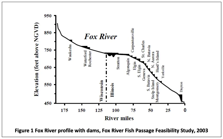
The change in the gradient or slope of the river can be seen in a profile of the riverbed from its beginning in Wisconsin down to the Illinois River (Figure 1). The river has an overall average slope of 2.5 ft./mi., dropping about 460 feet over 185 miles. The river does not have a uniform slope, between the state line and Algonquin, the river is extremely flat with an average slope of only 0.3 ft./mi. South of Algonquin to St. Charles the slope increases to about 2.0 ft./mi., between St. Charles and Yorkville the slope averages 4.5 ft./mi. and finally from Yorkville to Dayton the average is 2.7 ft./mi.
Flood Preparedness
Floods are the most common natural disaster in the Fox River watershed.
Along the Fox River, floods can occur as the result of rain, snow melt, and ice jams. Flooding on the main stem of the Fox River can happen slowly and flash flooding can be experienced, especially along the smaller tributary streams. With rainfall characteristics changing, i.e. more short-duration high-intensity rainfall events, there may be less time to build the temporary sandbag barriers that have provided the flood protection for many buildings in the floodplain.
Floodplain regulations are designed to reduce damages to development in the floodplain.
This is accomplished by restricting new construction or requiring protections for the both the new development and adjacent properties. The NFIP requires floodplain regulations be adopted and enforced to be a member community. Illinois requires higher regulatory standards than the NFIP, and in northeastern Illinois there are additional higher standards. In some cases, communities adopt higher standards. The three floodplain standards are:
- Flood protection elevation: the elevation that a new or substantially improved structure must be elevated to above the base flood elevation.
- Compensatory storage ratio: the amount of additional cut required if fill is placed in the floodplain.
- Cumulative tracking of improvements or repairs: to a building over a specified length of time, life of the building or from a specified date.
Stormwater regulations are adopted to both reduce stormwater runoff and to detain or slowly release runoff from a development.
Figure 1 Fox River profile with dams, Fox River Fish Passage Feasibility Study, 2003
More recently, stormwater ordinances have begun to require the infiltration of some portion of the runoff. This new requirement helps reduce runoff and helps capture pollutants carried in the initial runoff from a property. The comparison includes the volume of runoff that must be stored and infiltrated, and at what level of development it is required. Some communities that are experiencing redevelopment of existing neighborhoods with larger homes require this for small increases in impervious areas.
County stormwater management programs are able to address stormwater program management issues at a larger scale than many small community programs, especially in a highly dense urban area. Many small communities benefit from a county’s efficient use of resources to support and enforce stormwater regulation and avoid competitive easing of stormwater management standards for economic benefit. Counties may be better able to facilitate watershed-based analysis of stormwater management issues. Some counties have successfully implemented sources of funding that may not be viable for small communities.
Flood protection or mitigation are actions taken to protect a property from flooding. F
or this report, flood protection will not include flood safety measures taken to protect people from loss of life or physical injury. Flood protection can include temporary measures, long-term building retrofitting projects, and flood insurance.
The 2018 Illinois Natural Hazard Mitigation Plan prioritizes acquisitions, demolition, and relocation when making funding decisions. The acquisition of substantially damaged properties and repetitive loss properties are list as the second and third priorities for mitigation. Small structural projects are listed as the fourth state priority. Specifically, storm water detention projects, reservoirs, floodwalls, and channel improvements.
The hazard mitigation plans completed for each county in the watershed include some or all of the following property protection measures for buildings subjected to flooding. Each county hazard plan discusses these measures in greater detail. Each plan also identifies critical facilities, which when flooded pose a risk to the larger community. Property protection measures include:
- Building Acquisition and Relocation
- Building Retrofits – Elevation (Figure 2.21), Floodproofing or Barriers
- Temporary Barriers o Flood Insurance
- Regulations, Zoning and Comprehensive Planning
Flood Recovery
Typical recovery actions bridge the gap between emergency and normalcy. These actions can include providing temporary housing, reconstruction, event counseling and education. The following can be very beneficial to the community:
Apply for Grants.
FEMA’s Hazard Mitigation Assistance (HMA) grant programs provide funding opportunities for disaster mitigation both before and after events. FEMA administers three HMA programs:
- Hazard Mitigation Grant Program helps implement long-term hazard mitigation planning and projects after a presidential major disaster declaration.
- Pre-Disaster Mitigation Program funds hazard mitigation planning and projects annually.
- Flood Mitigation Assistance Grant Program funds projects and planning that specifically aims to reduce or eliminate long-term risk of flood damage to structures insured under the NFIP.
Document the flood.
After the flood waters have receded and it is safe to do so, mark high water lines and survey them to document the maximum flooding condition. Interview residents and business owners to collect information about their experience with the flood and the impact it had on them. All information collected can be used to justify the need for financial assistance, public education on the severity of the event and improve the accuracy of flood modeling.